Flickr Gets Geotagging
Online photo management and sharing site Flickr has just added the ability to GeoTag images. This is basically a means of identifying where a picture was taken by encoding the latitude and longitude in the image EXIF data. It was only a matter of time before Yahoo! added this into Flickr as arch rivals, Google have it running on the new version of Picasa and Picasa Web Albums.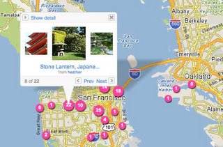 It's a very easy process. You just select one or more images from your collection and drag and drop them onto a location on the map provided from Yahoo! Maps. The only negative point is that Yahoo! Maps is not anywhere near as detailed as Google Maps or Windows Live Local, especially outside the U.S. Maybe this is the kind of exposure to public use that'll stimulate Yahoo! to improve it.
Still I've got over 700 images to tag, if I can find the time or inclination, so I'll be pretty well tagged out by the time I'm finished.
NB: While GeoTagging allows for altitude to be included in the data, it isn't part of the deal here and it would be pretty difficult to do on a two-dimensional map. If you really want to have that functionality, then go get yourself a GPS tracker or a GPS enabled camera.


No comments:
Post a Comment